....missing anymore!
We found it!
With all the park gates closing for the season on December 1st, we agreed to take advantage, one last time, of going into an area that we will be shut out off come next Friday night. Our choice to celebrate the gate closures was to go in search of Missinglink Mountain! The plan was to complete a loop which started from the Bighorn Sheep Lookout parking lot.
We hiked along the 546 to the Texas Gate.
Next we had 244 meters of cold turkey climbing.
We left the snowshoes in the vehicle for obvious reasons. Looking above and beyond us, I already knew that today I would surpass 600 kilometers of hiking so far this year. Trembling aspens lined the south-facing slope. At 9:30am as we ascended, the sun was already hot on my back and before long I had to double-delayer.
This herd of elk was an amazing sight and the thundering sound we heard was amazing too as they stampeded across the ridge. We soon realized by their behavior, we may have been causing them stress, so we quickly moved on with our cold turkey climbing.
As we entered the forest, we had to rely on the GPS, map, compass, written directions and our spidey-sense to find a way to the Missinglink Mountain summit. In a round-about way, we got to where we wanted to be then made a bee-line for the cairn once we spotted it. This was the first smaller summit cairn.
We carried on a bit further and reached this spectacular Inukshuk. Caboose took a little time and gave the Inukshuk some deserving attention by replacing the fallen rocks. What a fine moment this was, we finally found the summit of Missinglink Mountain.
My summit shot!
It was cool and windy on the summit so we headed into the trees for shelter, yet still in the sun and still with a view, for our lunch break. Our main course was topped off with Japanese candy treats, honey mandarins and those giddy-causing rum balls.
From this point forward, we only relied on the compass and GPS to find our way. We spent the balance of the day predominantly amongst matchstick pines, where the sun shone through creating wonderful shadows. The descent was gentle and once we reached the bottom, we came to a barbed wire fence that we climbed through and then discovered this on the other side! What on earth is it? UPDATE: http://www.hubbardbrook.org/w6_tour/rain-gauge-stop/precipitation.htm Thank you to Adventure Designer for a link explaining what this is.
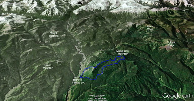
We exited the forest a few steps before the Bighorn Sheep Lookout parking lot where our vehicle was. Well, as you can see from our track on google earth, we did complete a loop although it was not our intended loop. There was lots of loosing and finding happening today and it was nice to now be heading home.
Just before hopping into the vehicle, I took one last photo of the antenna decoration.
It summed up today for me.
Bright, cheerful, happy!
The look on this face is exactly how I feel when I feel like I am
"on top of the world"!


That device with the ladder is a rain gauge. The 'can' in the middle is open at the top, and the outer pieces are wind screens.
ReplyDeleteWonderful adventure found out there! Loved the 'shadow image' too.
ReplyDeleteThe herd of deer is so impressive! Wow! Another exciting adventure in the life of Alexandra :)
ReplyDeleteVery sad to say that our beloved Inukshuk was destroyed near the end of Oct./2015
ReplyDeletehttp://kananaskisblog.com/missing-inukshuk/2015/
Joanne, I follow the kananaskisblog and read about that Inukshuk being destroyed. I felt sad too!
Delete