Saturday, March 26, 2011

Expensive Gem

Today, four of my friends and myself along with all our gear, packed into my brand new car to head west to go play in the mountains.  Today was also the first time I drove on the highway since Sunday, January 16, 2011!  I was glad to have my friends with me who were  first rate with their support in getting me past that nasty spot along the way.  Our trailhead for Opal Ridge South Summit was at the Fortress Junction Service Station.

We walked along the highway for half a kilometer before heading into the trees to begin our ascent bushwhacking up through the forest.  Once above tree line, we faced a very steep slippery sugary snowy slope.  We assessed that it was safe to continue and eventually got to a flatter space where the snow had been blown off from there on up, so changed from snowshoes to micro spikes.  We could see our destination, the top right peak.
We also had clear views to the north and south!
We created small switch-backs as we ascended to make it easier in places.  Certain portions that we traversed were covered in deep hard crusted snow.   I learned a valuable lesson on digging steps in that stuff.    After the tough (for me) sections were over, we found shelter from the wind and stopped to dine while enjoying the 
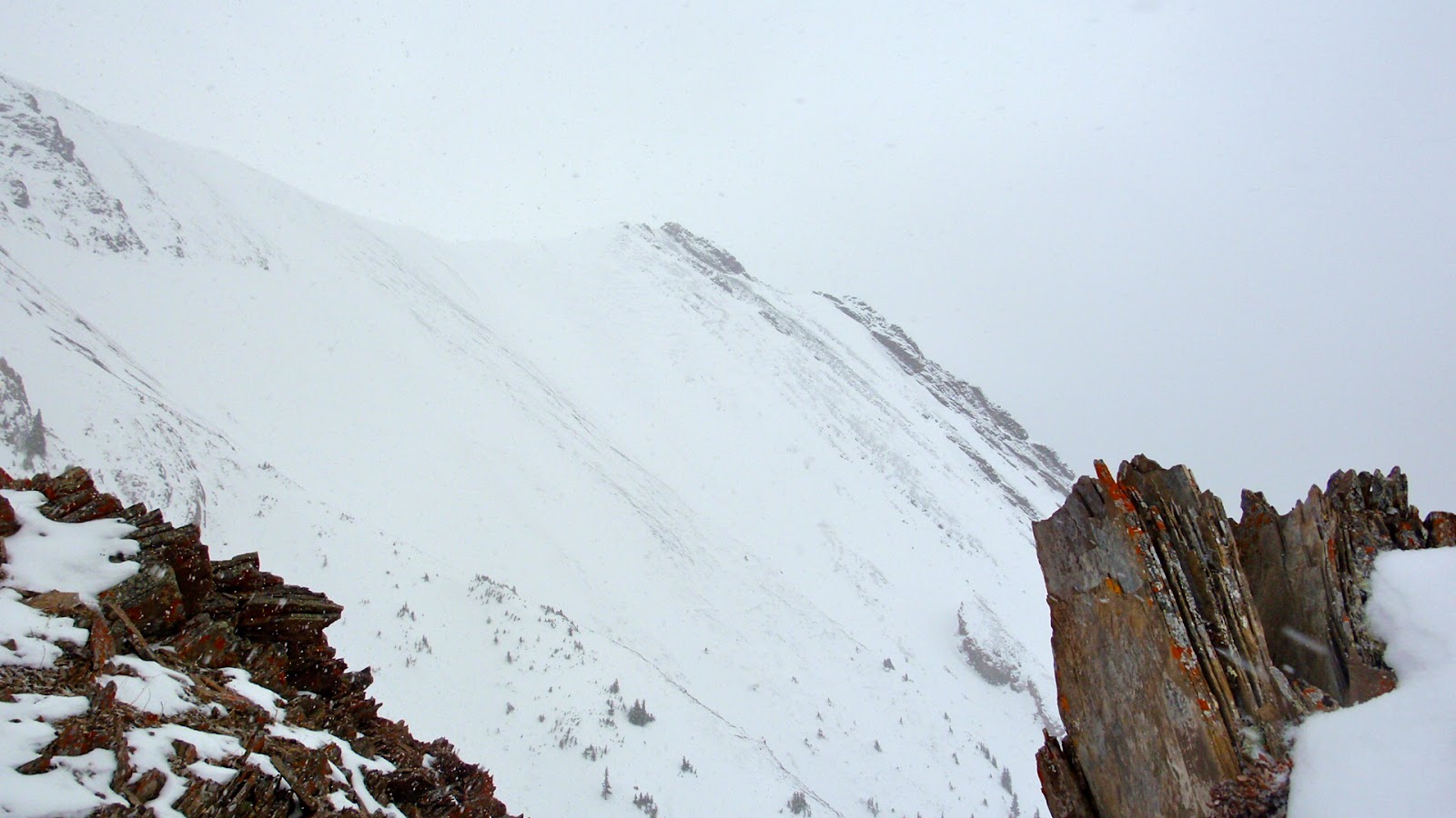
first class scenery.  Then it was time to push for the summit although we were not sure if we would be able to go all the way.  We could see cornices and it was getting on into the afternoon.

We could see the Gates that we had to pass through which are these splendid gigantic rocks that would guide us to a meadow with great views.
From here we could see our ultimate goal, the top right hand snow covered peak.  We decided we would have to save that for another day.
The top of The Gates was today's summit!  We dropped our packs and spent some time here scrambling, taking priceless group photos along with other great shots.  I had "peak" on my mind so meant to say "peeking" instead of "peaking".   This was an enjoyable space to be in, sheltered from the wind, touches of blue in the sky and a 360 degree view.

I found a premium spot for my summit shot!
I felt sky-high here!
She looks majestic!  The ewe, not me!
We were able to make somewhat of a loop today by descending down the ledges area instead of the way we ascended.  While ledges can be barriers, they were not today but this was a barrier.  The moose was getting its salt fix.  Next to the oncoming vehicle puts its size into perspective.  We had to wait it out and just made the best of our time snapping shots.  Finally we were able to go on our merry way for our reward at Woodys.
Today's adventure at Opal was one of those gem days!  You probably caught on why I called this post an "expensive gem"!  There are so many words to describe a day that is top rate from beginning to end!  Thank you to Adventurer Designer for today's design and for taking over the reigns in getting my car home safely in the dark stormy night!

Saturday, March 12, 2011

Sunshine + Scenery + Summit =

what I have been craving the past few weeks and that is feeling that feeling that makes me feel like I am "on top of the world"!  Today my craving was satisfied!  It wasn't just reaching the summit that did it for me, but a combination of that plus being with my friends and having lots of sunshine and scenery too.  The whole journey from where we met in the city to reaching the summit of Burnt Timber Lookout and back to the city again was one of those wild journeys.

The first portion of the trail was steep uphill through trees and through deep sugary snow which was slow going.  Thank you to whoever placed the ribbon markings.  That made route finding to the ATV Trail simple.  We then followed the ATV Trail which took us along a round about way towards a sheltered spot in the trees to have lunch before heading to the wide open space that would lead us to the summit.

We were thankful Mother Nature delivered on her promise of shining on us and keeping us warm while we enjoyed our journey.

SUNSHINE
When we emerged from the trees and hiked to the first part of the lower ridge and saw our destination and a 360 degree view, I was ecstatic!  We all pulled out our cameras and started shooting every which way.  It was so gorgeous!  It was wicked windy, yet a warm wind and when it blew strong, it sent a swarm of snow swirls scattering.

SCENERY
We slowly made our way along the lower ridge.   We climbed the last up hill part that brought us to the top.  The wind was strong but it was fun to experience it especially when we were taking our group summit photos.  You are probably saying to yourself by looking at my summit smile that "oh yeah she is feeling that feeling"!

SUMMIT
I was high on life from here on in!  We cut off time and distance by taking a direct route from the far end of the lower ridge back down to the ATV Trail.  We reached the vehicle in what seemed like no time and once there,  Ms D No Stopping Me rewarded us all with her home-made cookies.  I detected my friends were high on life too and what was talked and laughed about in the vehicle, stays in the vehicle!

I tip my hat to DGo&Go&Go!  Not only does she go and go and go on the trail, the drive today went and went and went on forever, all over creation, over ice, through mud, on top of snow, around dangerous curves and she got us there and home again safe and sound.  Thumbs up to Adventure Designer for reminding us today why she earned that name!

With all the sunshine and scenery and summiting, I know I will sleep soundly tonight!

Wednesday, March 9, 2011

Wondering Wednesday!

It's Wednesday and I'm Wondering!

 I don't believe it's all about peak bagging!
Why then am I feeling I need to be on a summit?

Saturday, March 5, 2011

Finding Bright

On a day that was to be cold and gray in the city, we choose to high-tail it away to Banff National Park where one thing was for sure and that was it would be lots warmer!  The plan was to snowshoe up to Twin Lakes which is in Banff National Park yet on the edge of Kootenay National Park in British Columbia and also boarding the Continental Divide.
Right from the get-go, we were in the trees and stayed there for 6 to 7 kilometers where after completing the first km, we began the 600 meters of elevation.  It was a gradual snowshoe climb along a week-or-so old trail so thank goodness for that.   What we knew going into this that was for sure, was definitely for sure.  The temperature hovered around 0C to -5C so thank goodness for that too!  The day was gray so it was hard to get photos that appeared colorful and bright. 
When nature doesn't provide you with cheerful, colorful and bright then you have to make it yourself!  I have knowledge in this field so put my expertise to work!  All it took was wearing the right shirt for the day and adding old man's beard to the mix.
Once completing the elevation, and reaching a wide open space, the last kilometer led us to the Lower Twin Lake.
We picked out our dining spot and it was decided right then and there that we would not be going on to the Upper Twin Lake.  I really wanted to carry on but had to go with the flow.  This was our summit for the day and this is my summit shot!  Lunch was on the quick side, we took a fun group shot, packed up then did the high-tail thing again.  I prolonged the leaving, kept looking back, I didn't want to go!  
When I realized that I would not get gorgeous big mountain scenery shots, I needed to save the day so went the route of artistic and unique.  
In the quickness of everything today, I also quickly tried to save my track but hit clear instead.  I made up a track where the pink dots show roughly the route we went.  Before accidentally hitting clear, I remember seeing 17.2km, 600 meters of elevation and 7 hours so thank goodness for that too!

Early on in today's trek, I knew I want to come back here!  I want to see this place on a nice summer day when there is plenty of time to explore and savour and see and where "quick" will be non-existant!  YES!  I will be back!

Ready Willing & Able!