Saturday, July 28, 2012

I Need To Go Again

As you can see from my Peakery Badge, I have been to Paget Peak twice.  
I need to go again! 
I am not sure when that will be, but it will be!
The first time we unknowingly only made it to the false summit and I came above bruised and bleeding.  Today we made it a little further to the true summit but yet, I still came away bleeding and bruised.  My goal for the yet to be third time is to go further then the true summit to where the truly gorgeous views are and come away unscathed.  

We started the day bright and early with bright skies.  
It didn't take long to get to Paget Lookout.
The higher we went along the steep section, the bigger the views became.  
This is looking west towards Field down in the valley.
A full view of Sherbrooke Lake came into sight.
We are warned that somewhere down there roams a grizzly bear.
We did see recent diggings along our trail.
We reached the false summit under dark clouds, light sprinkles, strong winds and a cold temperature.  I came prepared to celebrate and no matter what, that was going to happen as this year is a special one.  So here I am on the false summit with one of a dozen "Bliss" mini cupcakes.  Mine was chocolate with green mint flavoured frosting on top decorated with a blue candle.   Thank you to my friends for sharing today with me!
The Peak was colorful and rocky!
We cut our lunch break short as the weather was deteriorating and we wanted to make sure we at least made it to the true summit.  You can see the summit canister at my foot.  If you reach the true peak be sure to peek in the canister.
The views were great from here considering the weather wasn't.  A little further along this trail though, I hear the views grow from great to spectacular.  Mount Niles appears to be surrounded by a collection of new snow.  
Three times here will be the charm!  
The following sights are not charming!
War wounds acquired on August 13, 2011.
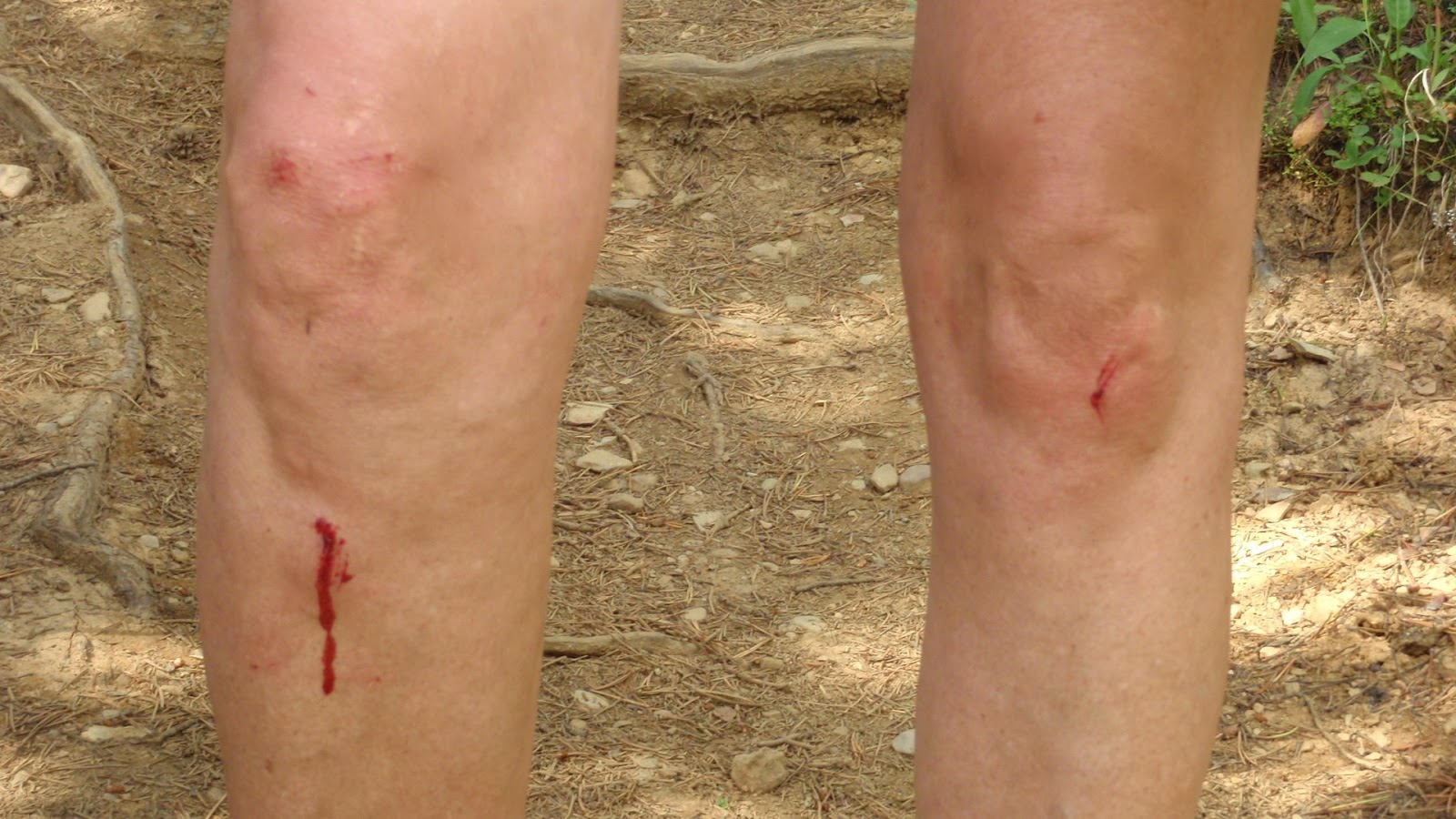
War wounds acquired today!
The descent off Paget Peak was slow going over scree, big rocks and through a boulder field all the while raining, changing to light hail then to sprinkles and when we arrived back at the Lookout the sky cleared, it warmed up, we dried off and landed back at the trail head pleasantly depleted.  It was such a treat to get the socks and boots off and change into clean cloths for the long drive back to the city. 

When I reflect back on today, I was glad to be able to share it with some old friends and to make some new ones.  I have been lucky to experience some wonderful adventures this summer and there are still more to come that have the potential to be bigger and even better.    I feel like I am the luckiest girl on earth these days!

Saturday, July 21, 2012

Talk About Being Long!

I made it official very early in the week that I would be hiking the full Mist Ridge Rickerts Pass Loop today and the effect I felt from the early declaration was that it made it seem like an extra long work week waiting for Saturday to come!   I had done a portion of this hike a few years ago but I had heard the part that I didn't complete was the most beautiful so I just had to go back and prove my source right.
We had a very early start to our day and that is just how I like it this time of year.  We were first in the parking lot trail head and first on the trail and saw only a dozen or so folks the balance of the day.   I don't understand why this is not a busy place but I sure like that it isn't.  When we finally got out of the forest, the views were spectacular immediately as seen in the photo of Mist Mountain below.
On the slope heading towards the south summit, I spotted these golden spotted eggs in a tiny nest nestled against a rock. If I had been a foot or two on either side of where I was, I would have passed right by.  I have no idea what they are. 
The south summit at 2432 meters.
View as we hiked along Mist Ridge.
There are lots of ups and downs on this long ridge.  We could see our last high point which is the north summit at 2515 meters.  It is the last beige bump and it looked like we still had a long way to go to reach it.
Two of my friends enjoying the Ridge top.
We reached an opening through a valley between two mountains and this is what we saw!
Calgary is a long distance away but it doesn't look like it here.
We made it to that last beige bump which was the highest point on Mist Ridge so this is where I choose to have my summit shot taken.  The long valley far below and behind me was an amazing sight to see.
We began our descent and headed towards Rickerts Pass.  I looked back to see a short portion of the long ridge that we just hiked along.   The tiny dots on the far right side of the ridge are two folks who also came to unbury this treasure.
We reached the official Rickerts Pass and wondered what this cross stood for.
Would any of you, my followers, know?
Every time I am out and about in my playground, I am thankful and very appreciative that I have my health, the time and the little bit of money that it cost to be able to enjoy what truly brings me joy.  Out of all those times, every once in a blue moon one of those times feels extra special and that was the case today.  I can't exactly put my finger on why those once in a blue moons happen, but when they do, I feel like I am "on top of the world!"

Saturday, July 14, 2012

The Unexpected!

Within 20 minutes after we sat on the bottom stair with books and maps, our plan for today was fully revisited then totally revamped.  We shifted our focus from one P to another P to better manage the possibilities Mother Nature could potentially present today.  Instead of Piran we went with Powderface.  

One part of the original plan that didn't change was to try my new backpacking boots. I did carry my Asolo Styngers in my pack just in case these new boots made my feet scream.      
It was nice having a quick drive to our trail head and being the only ones there.  Five minutes into our hike, we realized we may not have the pleasure of owning the trail today.  We were not expecting a trail full of trail runners, and then came my old hiking buddie running the Transrockies race.  You never know who you are going to run into in the mountains.  
This onslaught of runners was short lived and then we took ownership of the trail.   I soon realized today was not going to be the greatest for scenery shots.  The low lying cloud hung around the entire day.  At times it was erie as we saw the low clouds come towards us, envelop us and then move past us.  
eyeing Nihahi Ridge
photo by Happy Hiker
Before heading up to the Ridge, we took the optional outlier detour from the Pass.  
I was here, at the Pass, on March 24th of this year when it was snow covered.
Today it looked like this.
I brought my guide book along (purposely adding extra weight) so we could check out other options along the way.  Happy Hiker was happy to read all about the area we were in.  I didn't expect my GPS to malfunction so the map and book came in handy.
My summit shot at our high point!
Another unexpected today was the quantity and variety of wild flowers.  
Approximately three quarters of the way through today's hike, I tripped on a rock so looked down to see and then remembered I had my new boots on.  Now that is a good sign!  They were proving to be very comfortable.  As it turned out, I didn't need to change into my old boots and arrived back at our trail head still wearing the new ones and my feet feeling very happy.  We covered roughly 10kms and approximately 490 meters of total elevation gain.  The next test for my boots will be covering more distance, more elevation gain and carrying more weight.
I was pleased that "The Unexpected" today was all in our favour!  

Saturday, July 7, 2012

Pigeon Offered a Bird's Eye View

Today's attack plan for Pigeon Mountain was to give it the credit it is due and to do it right this time!  My friends were all on board with my thinking and most importantly thank you Mother Nature, so were you.  The main objective was of course to reach the cairn on the true summit of Pigeon Mountain to where we would have a bird's eye view down into the Bow Valley, Canmore and of all the surrounding mountains.  That cairn is on the tip of that beige looking rocky bit at middle left in the below photo.
The second objective was to explore and discover what was up on top of this ridge.
The first four to five kilometers of the hike are boring because it follows the Skogan Pass Trail which is entirely in the trees.  It is worth it though to put up with this because then it is nothing but wide open spaces where you have that bird's eye view and can see forever.
We took the higher trail to reach the first (false) summit so we could admire the valley below....
....and the colorful rock formations.
 Then it was on to the true summit at 2394 meters (7855 feet.)
This was a much more enjoyable summit visit....
 ...from the one I experienced on November 5, 2011.
We had time to dine on the summit, nap and play photographer.   
A bit further down from the summit cairn was a perfect spot to take in the view.  
After our main objective was conquered, it was time to carry on to see what was up on that ridge that just stands there looking very inviting.  
We found a defined route and followed it.
In no time at all, we were on the top!  I was surprised to discover a big beautiful green meadow covered in wild flowers.  There is more exploring to do up here but that will have to wait for another day.  We had a great view of Pigeon Mountain.  The summit from where we just came is at the tip of my left shoulder.
 The door was locked!
 We descended the way we ascended.  See my two friends in the cloud?
I was pleased we were able to accomplish both objectives today.  More often then not, mountain summits are a very windy and sometimes cold place to be but that wasn't the case today.  It was hot with the odd tiny slight breeze which made for ideal conditions for an extended summit visit and for taking the time to explore.  It was rewarding to accomplish doing it right this time and that made me feel like I was "on top of the world!"