Sunday, August 28, 2016

Mount Kidd Outlier worthy of framing

I have a small notebook that is in my purse at all times.  It is a place where I jot down thoughts as I think of them, and the thoughts are of mostly peaks, passes, lakes, mountains that I want to visit one day.  One site that I follow, he calls this type of thing his "wish list".  I flipped back through the earlier pages and a few years ago, I jotted down Guinn's Pass & Mt Kidd Outlier. It peaked my interest once again and I thought there is no time like the present to get on up there.

This is what I mean by being "worthy of framing"!


With Saturday being a day planned full with life's happenings, Sunday was the get on up there day for this weekend.  When doing my home work and checking my many sources for forecasts, I could find no two the same.   This summer I have been spoilled with being in the right area of the vast playground at the right time for awesome weather.  Today seemed like that trend could end.  The fog was dense as we hiked along the Galatea Creek Trail.
We made excellent time getting to the junction for our turn off for the Guinn's Pass Trail.  The air was still and heavy, it was actually hot and humid and so very damp.  We could see nothing and the thought went through my mind is this steep gnarly climb up through the gully even worth it.  As we came out of the forest and we were nearing the Pass,  tiny bits of peaks began to peek through.
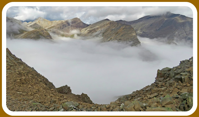
Our pace slowed down considerably as we kept performing 360 degree turns ooooohing and aaaaahing at what was developing right before our eyes.  We reached Guinn's Pass as the fog that remained was all below us and grey clouds were above us.
framed by fog and cloud
Autumn is in the air as seen from the ground cover color.
Our destination appears in the air too, that high peak in the middle.
We finally reached Mount Kidd Outlier.  It was simple to get to from Guinn's Pass.
We scooted on down the other side of it for an optimal dining location.  There was more flat room for the six of us to spread out and get comfy.  This was my lunch time view.  I watched the fog and clouds roll in and out offering up various views of peaks peeking through.
After lunch, we spent a little time taking photos.  
Bits of blue began to show through.  
Looking off towards Buller Pass.
Ribbon Lake is down below somewhere.
I had numerous summit shots taken.
I opt to share this one.
the six of us
looking back at Mount Kidd South Summit 
resting on the love seat
We aimed for Guinn's Pass again on our way down to take a couple of minutes before entering back into the dense fog.  The Pass is in the center with fog on either side of it.  More and more blue began to appear and it made for a photographers' dream.
descending into the fog
Before being fully enveloped in the fog, I took one last look back to snap one last shot.
There were still loads of widflowers along the steep rocky gully.  It was past prime time for them but they added color to an otherwise brownish area.  My friends are colorful too.  The fog stayed with us the entire way down the Guinn's Pass Trail and even along the Galatea Creek Trail.  When we arrived back at the parking lot, the tips of the surrounding peaks were still hidden.
Along the Galatea Creek Trail we met up with the Search and Rescue group.  I felt mixed emotions seeing them at first, thinking they may be officially performing what they are trained to do meaning someone was in need, and then it was comforting to think maybe they were there for someone who needed them. That was until we took a few minutes to chat and find out they were training and practicing.  As I found out, one member is a loyal follower of my blog.  It was so nice to meet you today.  Thank you to each and every one of you and all other members of all Search and Rescue teams for doing what you do.  

If life's happenings were not taking place on Saturday, I would have been up on this Pass and Outlier. While it might have been a good day, I have a sense it would not have been as frame worthy as today was.  Also, I would not have had the opportunity to share the Saturday with these friends as the majority all had other plans in place.  I like how life at times has a way of playing out perfectly.  In all its' fog and eeriness, today was picture perfect, enough so that I had to frame it!


Saturday, August 20, 2016

Castle Mountain Queen of the Castle

I never had intentions of reaching the summit of Castle Mountain.  I was content with just looking up and admiring the majestic mountain.  A couple of weeks prior, I heard someone mention the name and for whatever reason it implanted in my brain and I could not let it go.  I gathered some information from Agent X and Michael JC, I bought Scrambles in the Canadian Rockies by Alan Kane, I downloaded two gpx files.  I received pertinent info from Adventure Designer and Smuts-Fist.  Yes, I did my homework and after doing so and coming to the realization that I believed I could stand up on top of Castle Mountain where that red star is, I put an invite out with hopes of getting a few experienced & supportive friends on board and I got exactly what I wished for.  
We got an early start and made good time ascending along the 7.4 kilometers long boring tree-lined trail up to Tower Lake.  It was as we arrived here where the view opened up to present to us the work we had in front of us to get to our destination.
Tower Lake
We took a break to fuel up.
Our destination is the top of the mountain to the right of the V.
We worked our way up to Rockbound Lake, took a few photos, checked out where we were headed next and then began the steep climb up to the plateau above the Lake.  It was quite warm by now with no breeze but thank you for the few fluffy clouds.
on the plateau above Rockbound Lake with our destination at the top left to the the right of the V
view as we worked our way even higher through the pleasant grassy meadow area
Rockbound Lake below me
I felt like I was on another planet.
Incredible view of all the Peaks & Knobs
The type of terrain we were traversing was new to me.  I enjoyed the variety and there was never a dull moment.  We passed over a gully that offered up this vantage of Rockbound Lake below Helena Ridge.  That lake looks like a jewel.
We passed by another gully on the opposite side that gave us a sneak peek of Highway 1 below us.
Yet even higher with another vantage view, I knew it was time for one last photo before making the final push to the summit.  I carried a photo of me and Ian in my pack. It's one of my favourite photos of when we were children.  I thought of Ian and knew he was right there with me because I felt this incredible burst of energy with only a few more minutes left to go.
I arrived at the top overcome with emotions.  
I tried to hide it behind my glasses by no luck.

After gathering my composure I secured my first summit shot framing Mount Temple with my victory pose and hoping my friends were accomplishing the same success with their summit bid over on that Mountain.  
Queen of The Castle
We spent about 50 minutes on the summit sharing it with a few others.  
I settled down to dine with this view in front of me.    
Eisenhower Peak
my five friends and me
Queens & Kings of The Castle
After investing the lengthy amount of time the summit of Castle Mountain was worthy off, we began the very, very long journey down.  The views remained incredible. We took the high trail to circumnavigate our way around the upper plateau above Rockbound Lake.
getting lower
me & Short Stop
the hue of our shirts blend nicely with the Lake
Now back at Tower Lake we had all the hard work behind us.
We had the last seven to eight kilometers to get through.  
We put our heads down, aimed down through the trees over all the roots and rocks.
Eleven and a half hours later, we arrived back at where we began our day.  Even though my dogs were barking (for those of you not familiar with that term, it means my feet were sore), I still felt as high as I did when I was on the summit of Castle Mountain.  We stopped in at Castle Village for an ice cream and while savouring that, I also savoured a few more minutes looking up to see where I stood a few hours early.
This was an incredible day for me.  I was thankful to be in the company of experienced, encouraging and supportive people.  I felt like I made leaps and bounds growing as adventurer.  It was an empowering feeling to be on that summit and also to complete this hike/scramble with only sore soles of my feet.  

Thank you for this day!


Saturday, August 13, 2016

Mist Ridge prettily packed

I wanted to make a meander on Mist happen with hopes of coming away with many memorable moments.  Mmmm, Mother Nature are you going to cooperate was on my mind!  I put the mention of my plan out there and much to my delight many friends motioned their approval by jumping on board.  The Mist Ridge & Rickerts Pass Loop would be my biggest hike this season with many kilometers to cover along with many meters of elevation gain and many hours on the trail.  I was motivated and ready.

our view as we crossed Highway 40 to the trail head on the other side
We spent close to two hours in the trees working our way up and towards the Ridge.  It was warm right from the get-go but we just put our heads down, kept on the quiet side and got that business done.  Then WOW that climb now became worth the effort when we were offered up views like this.
After reaching the south summit we had a chat with a group from Outward Bound and I believe this link would be the group and the event.  We then carried on and began our up and down meander along Mist.  Enjoying the beauty and the peacefulness, right out of the blue from the ridge in front of us, along came this plane so close I felt like I could reach out and touch it.  The pilot tilted back and forth acknowledging us with a wave.  I was able to quickly snap this shot after he passed us. Talk about exciting and creating an adrenaline rush!
view along Mist Ridge
my destination shot along Mist Ridge
a dip along the way and opening up a view of forever
I quickly moved ahead of my friends so I could capture a photo that puts this Ridge in perspective.  We just descended from that high point and were now beginning to ascend to another one.  We enjoyed roughly 10 kilometers of views, terrain, ups & downs like this along the entire length of Mist Ridge.
You can see the whole line of peaks we still have to reach.
my fun friends & me
We thoroughly enjoyed the scenery,
being buzzed by the plane,
 and on top of that
we got to watch a cavalcade ride by.  
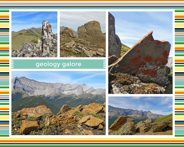
The entire stretch of the Ridge was covered in rocks & boulders & slabs of all sorts.
I would suggest this Ridge to be a geologists dream.
stopping for a short rest along the way
We finally reached the north summit of Mist Ridge.  This is my destination shot at this end.  From this point forward we had a short scramble to a rocky high point and then it was all down hill from there.
coming down the grassy slope towards Rickarts Pass
We arrived at Rickerts Pass.  We took a second lunch break here to admire the scenery, rest a bit and fuel up for the last eight kilometers back to the trail head.  Getting through this distance to come would be back to putting our heads down and getting that business done.
a few short minutes before arriving to where we would be calling it a day
This day will be a memorable one for me.  
I would not have asked for it to play out any differently than it did. 
Mentally & physically I felt like I was "on top of the world"!