Friday, October 2, 2015

Moab Day 6 Island in the Sky

We have been pushing this day forward for a few days waiting for a favourable (cooler) forecast and that day finally came.  We left home early to arrive early at Mesa Arch in the Island in the Sky district of Canyonlands.  The plan was to watch the sun rise.  After that, we would enjoy breakfast and then hike the Alcove Springs Trail.

We arrived at Mesa Arch parking lot to see only a few other cars.  I was O.K. with this, I did not want a coveted spot at the Arch but I hoped there would be some vacant space. We hiked the kilometer in the dark and upon arrival, I told my friends how it worked and what the lay of the land was. They maneuvered in and got their coveted spots.  I stayed to the right this time.

                                                  the sun begins rising
                                         the underside of Mesa Arch as the sun rises
We stayed a little while to get a few photos from different vantage points then decided it was time to carry on with our day.  I took one last look back from up along the trail to see a few folks still savouring the scene.
Then there was no more looking back, only forward.  Then I saw our shadows and thought of sun and heat.  But today would be cooler!  We made our way back to the car, it was feeling warm so layered down, then had breakfast.
                                               
We reached the Alcove Springs Trail parking lot.  It felt cool enough that I did not bother zipping the bottoms of my pants off.  We climbed down, then down, I am wondering, then down some more, It feels hot....
                                              
.....I am thinking, even more down, it feels hotter, down some more, I begin to worry, then I make my declaration!  This reminded me of going down into the Grand Canyon.
It was getting hotter the further down we went and I was concerned with it reaching 100 degrees F and climbing back out in those temperatures.  For me, safety always comes first and I needed to play safe so decided I would not be carrying on with this hike. We were not even at the bottom yet, but this was my turn around point.  The others were OK with this, so our climb back up began.
Back at the car, we revisited how we would attack today and agreed upon hiking a few shorter overlooks.  The first then would be the two overlooks at Upheaval Dome.  As it turned out we were able to hike up to 5 kms of ground cover on each hike so our total for the day did tally to high. This was the view from the first Overlook.
                                     our group shot at Upheaval Dome Overlook
                                     view from the second Overlook
Going beyond the second Overlook offered fun route finding and scrambling along on slick rock.  We thoroughly covered lots of area here then began the hike back.
 
Another overlook where we could get some distance would be the Murphy Overlook.  The trail head is the same as that for the Murphy Hogback Loop which I did back in the day but you stay straight after a short distance of hiking.
                                              view along the way
                                       just before the main overlook area
After reaching the Murphy Overlook, we explored a bit to find an area not so windy where I could safely set up my tripod.  This is our group shot, sitting safely from those wind gusts.  We snacked then began the hike back.
Visiting the Grand View Point at the end of the road was next.  This was another overlook where we could pack on a few more kilometres.  Large cairns showed us the way.  We had grand views far below and beyond.
                                                 view along the way
                                                              at the end
It was crazy windy by now but I was fine with that. It kept the temperature at a decent digit which made for enjoyably being out and about.  Beside this boulder section was a lovely shaded spot, we made it our place to dine so settled down for a visit.  Then it was time to hit the trail for one last look out before heading home.
That one last overlook was the Shafer Overlook just off the side of the road, so no hiking necessary.  If you look closely in the shade on the bottom left, you will see the vehicle we watched slowly maneuver along.         
We put our experience to work today and found a way to save the day.  I enjoyed seeing the many different sights.  We still worked our way up to just under 20 kms of hiking.  


Thursday, October 1, 2015

Moab Day 5 Fisher Towers & Morning Glory

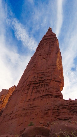
Fishers Towers

A closer day to home was needed today in preparation for tomorrow.  Though, we still packed in 20 kilometres of hiking on possibly the hottest day yet, it may have hit 36 degrees Celsius.  Our drive was short so we were able to be home earlier to rest and prepare.

We arrived soon after sunrise to hike the Fisher Towers trail.  I hiked a small portion of it back in the day, today's plan was to head in further and higher until we could go no more.  There were two other vehicles in the lot, so others also wanted to beat the heat while climbing.  It was very soon into the hike when the views opened up and we had them the entire trek. 
What was not to love here, we had pinnacles, spires, towers, blue sky, clouds, some hiking, scrambling, route finding, a ladder, a natural bridge! We had it all. We worked our way in behind the Fisher Towers....
                            .... to where we had a full on golden view.
                             The further in, the closer we made our way to The Titan!
                                        
The sensational scenery was never ending.  There were so many unique things to admire, big and little, like this display of mini cairns.  Back and beyond, we did fully rely on cairns to show us the way.  They lead us....
....to more and more beautiful views.  The ground cover was fun to be on, it is amazing how sticky that slick rock is and how so sturdy you can be on steep slopes.  The clouds danced all day and as the morning went on, a breeze developed.  My hope was that it was bringing in cooler temperatures.
                                                seeing forever
                                                    The Titan from further back.
                                    
We made our way to our planned spot and stopped for snacks.  It was still too early for lunch.  The place was a bit precarious for destination shots so opted to save that until later.  This is that later spot.  We purchased technical shirts at Dead Horse yesterday, so decided to wear them today and present a pose to show them off.
                   my happy to be here shot up front and Center with The Titan
On the return portion of the hike, we found a spot in the shade for a proper lunch to fuel up before driving down the road to begin our second hike of the day, into Morning Glory Bridge.  Today I felt like maybe I was getting a handle on hiking in the heat.


Morning Glory Bridge

After not that long of a drive, we arrived at the parking lot for the hike into Morning Glory Bridge.  By now it was scorching hot again but I remembered this hike having shade and lots of time beside a creek and pools of water.  I was surprised the further in we hiked, the damage to the trail we found.  There was obviously flooding since my visit back in the day and the trail was unrecognizable in parts.  There was a bit of route finding too because of the damage.
colorful cactus
There were many many creek crossings and I was thankful for that.  I cooled down my hands every chance I got.  In sections, the pools were large enough to offer up reflections and of course, I needed to capture that. 
We arrived at Morning Glory Bridge and enjoyed the shade and the reflections and a snack.   I stood under and looked up and remembered when I repelled off the side of the wall next the Bridge.  
reflections

After our snack and savouring sthe peace and quiet, we made our way back along the trail.  
I took one last look back and one last photo of where we just came from.
Today, I looked forward to getting back to our home away from home and enjoying more time relaxing.  Our days have been long and busy and I really needed some down time.   It was a short drive and I was luxurating in no time.

I have no BaseCamp info or elevation profiles to share for these two hikes.  I accidently deleted them from my collection and had already deleted them off my GPS.


Wednesday, September 30, 2015

Moab Day 4 Dead Horse Point State Park

I"m trying to mix up our days with aiming to different directions that present us with different landscape types.  There was an original itinerary which we are altering a bit, saving a bigger day for the forecasted cooler day, but those cooler days are just not happening.  Dead Horse Point State Park will give us everything but elevation gain.  That is what bothers me most when it is 90 degrees F.  I have been adjusting my food and liquid intake to find that winning combination and I am getting closer.  

For this hike I knew we would be up the whole time, I completed it back in the day. We started up and ended up, the whole while in between we were eyeing across and down.  The trail is cairned the whole way but you don't necessarily look down for the next cairn.
Along the beginning wall at Dead Horse Point, I spotted an opening at ground level that looked too perfect to not be purposeful.  I held my camera down at ground level and did a point and shoot not knowing what the outcome would be, well this is what I got.
                             The Colorado River meanders through the canyon.  
It was another day of pretty clouds, lots of vibrant greenery and those beautiful ugly trees.
At every overlook, we stopped to give it the time deserved.  Those were good times to snack and to refreshen our cool neck ties.  Speaking of necks, the neck leading to each overlook was pretty on its own, and I wondered what was at the end of each.  I realized it was long enough ago that I did this hike, it was like new again.
                              
                                        my destination shot at Shaffer Overlook
                                   feeling like we could fly at Shaffer Overlook
We hiked all overlooks with the last one being the longest at Bighorn Overlook. We made this our dining overlook and this was my view.  Those are the LaSal Mountains left of the Utah Juniper. This was peaceful and private and pretty.
                                      A few of the pot holes contained water.
We made our way back to the main trail which would bring us back to the Visitor Center and the completion of our star shaped hike.
                                     
With this hik now completed, it was time to get on with the balance of our day. We have been so fortunate to have such beautiful days and seeing such gorgeous scenery, I am very thankful for this.


Tuesday, September 29, 2015

Moab Day 3 Druid Arch in The Needles of Canyonlands

Today's early start south on the highway towards The Needles district of Canyonlands Natiional Park afforded us a magnificent view of once again, a land like no other.  The sunrise added pretty colour to the sky and the monuments.  We were early enough that we arrived to the Visitor Center to witness the  raising of the flag just before the Center opened.  I captured a couple of photos before walking through the front door.
                                                  the setting moon
After purchasing our park pass, we made our way to the Elephant Hill trail head to begin the hike.  I was still feeling off from the heat from yesterday and was waffling on what I would be able to accomplish today.  After a few breaks,  pacing a bit slower, I began to feel human again and at the junction made the decision we would stick to the original plan of going all the way to Druid Arch.

The scenery and trail variations were outstanding right from the get-go.  We had it all, the red slick rock, the blue sky, the scattered cloud designs, canyons, washes, boulders, needles, mushrooms, a ladder, stair cases.  
                                  it was ever changing from red to gold to red to gold
                   Before dropping down into Elephant Canyon, we could see forever.
I was curious as we made our way through the slot canyon, what would we see at the other end.
                                            
The needles were well defined and looked spectacular against that blue sky.  It was tough going at times along the canyon floor where there were lengthy sections of sand.  I looked for flat rocks and compacted sand to walk on to save my legs and my energy.  
                                  There was one area that was full of boulders.
From beginning to end, there were cairns to guide us.  They were in unusual places at times and that made the cairn finding that much more fun.  Along the wash, there were many shady sections so I took numerous breaks in those spots as we went about our day.
As the kilometres were passing, the terrain changed and the anticipation climbed. It felt like we were approaching our destination, yet then we had to climb and climb some more.  Nearing the end of the canyon, it opened up.  After ascending the ladder and then a little more scrambling and route finding....
                                         
                .....there it was!  Druid Arch!  It was boldly beautiful and magnifently majestic.  
There would be no standing under this arch, so this was the ideal location to secure my destination shot.  After that business was taken are off, we settle in shade to dine.  I did not have much of an appetite, so only savoured some of my sandwich, grapes, apple slices and a portion of my power bar, oh and some sesame snacks.  They were my saving grace today, settling my stomach and they were my salt supply.
There was another saving grace in my day.  I call her  "A Reason"!  She was a soloist trail runner who arrived at The Arch shortly after us and left shortly before us.  As we were nearing the steel bar across the slick rock slope just above the ladder, I became anxious about crossing and descending.  Then "A Reason" reappeared, she went a bit beyond the turn off point then came back to this sketchy section arriving at the same time as us.  She was my saving grace in guiding me through this section.  I let out a sight of relief once I was back at the bottom.

Then it was back to the wash and the canyon following along for many kilometres until we came back up and out the other side to those wide open vistas.  It was smooth sailing from here.
                           a grand vista with the LaSal Mountains in the far off distance
This was another huge day and I just wanted it over with and to sit on something soft without boots and socks on.  Once that was accomplished, I felt human again and could smile again, and relive what a fabulous day we just experienced and it truly was an adventure to remember.