Sunday, November 29, 2009

Running Log


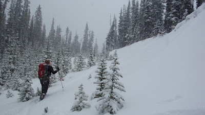
It's still only 2009 but I am ready for 2010!  Well, only when it comes to recording my running mileage.  I received my running log from www.personallogs.com the other day.  You get to choose what you want on the front and because I don't have a good running shot of me, I picked a hiking picture.  This photo was taken on the top of Fairview Mountain near Lake Louise.  Even though it is not a running photo, it still embodies the idea of healthy lifestyle, enthusiasm and growing by pushing limits and going beyond comfort zones.  I will have to work on a running shot for the 2011 log.

This morning was the first time I ran since the Halloween Howl 10km on October 24th.  Well, unless you want to count Friday's run home from work in blizzard like weather wearing heels, suit, long coat, carrying a purse and small pack over my back with a pink silk scarf wrapped around my head.  When I think back, that must have looked pretty hilarious.   I don't care, I needed to get home!  For this morning's run, I purposely left my watch at home and just went for it.  It went fine, I did roughly 5km with a couple of stops for lights and a walk break or two.  Good thing at times I had the chinook winds at my back. Boy, I have a lot of work to do to get back up to snuff.  Good thing next weekend's run is short and a fun one.  I registered for the Salvation Army's 5km Santa Shuffle.

Saturday, November 28, 2009

When You Gotta Go....

....you just gotta go!  That was how I felt today and as I headed out the door I had no idea where I was going to end up or what I would see!  It depended on the road conditions after yesterday's nasty surprise and what a nice surprise today turned into!  I headed west and this is where I ended up and this is what I saw! I had lots of time to seek out the unusual and funny and amazing and beautiful!  What a great time of year to find icy things!  Like
Golden Nuggets

Lollipops

Ice Dragon

I drove down Highway 40 (the saying is "life begins at Highway 40") and stopped at Wedge Pond, Mount Lorette Ponds, Barrier Lake and Ribbon Creek.  What a great time of year to see any kind of body of water.  Like
Barrier Lake

Ribbon Creek

Wedge Pond

After a couple of hours of trying to play professional photographer, I settled down for a picnic and tea time along side Ribbon Creek. I had no intentions of thermos/attire matching, it just happened.  I had the Creek to myself and lavished in the sun, sipping raspberry tea and savouring a blueberry scone, garden vegetable Havarti cheese, mixed veggies, buffalo wing flattened pretzels and of course to top it off, a two bite brownie.

With the sun shining and cooler temperatures in the mountains, this is a great time of year for  vibrant colors.  Like
Green Colored Rocks

Bold Green Ripples

Green Reflections and Swirls

What is a day in K-Country without seeing some kind of waterfall.  My last stop was O'Shaughnessy Falls.

These are just a sampling of the over 200 photos I came away with, and of the 50 or so which I kept.

You don't have to be up high to get that special feeling.  Today involved no elevation, I remained at road level but yet by taking the time to stop and smell the roses, I felt like I was "on top of the world!"

Saturday, November 21, 2009

Enjoying The Journey No Matter What

Over the past couple of days, there were many emails and discussions on where we should venture to today. When it came down to the second do we drive straight or turn off right here, was when the decision was finally made to tackle Tent Ridge. I had checked the forecast before heading out the door and it looked like we would be in for a sunny, gorgeous afternoon! What city was that forecast for?

This was what 99.9% of today looked liked for us! Snowy! Cloudy! It all started 15 minutes into our 5 hour snowshoe trek, with a break of about another 15 minutes mid way.

I thought today could be an opportunity to improve upon my slippery slope snowshoeing skills but it turned out being an opportunity to practice our route finding skills, log climbing skills, remaining upright skills, keeping warm skills all while still managing to have fun because it truly is all about the journey and not the destination. Today there turned out being no destination unless you want to call the Grizzly Paw in Canmore a destination!

We started out with 2 functioning 60 CSXs. G-Force had the route loaded on his and eventually was able to find a trail to follow. Nothing looked familiar from when we did it on July 1st, yet we carried on. The visibility was not much beyond what was in front of us, yet we carried on.

We realized early on that we were faced with a tough challenge and already we were questioning how far we could get. I thought to myself that today then had to be all about the journey and making the best of the situation and enjoy it no matter what. Be happy! Don't worry!

Take the time to play and have fun! Enjoy the scenery plus the quantity and quality of snow.


After 3 hours and covering, maybe, 3 kilometers, we thought it best to break for a well deserved lunch and then trace our steps back. We still had no real idea of where we were, still could not see any evidence of a Ridge, the snow was getting heavier and knowing this time of year how the daylight hours are shorter, we would have to call it a day after lunch.

I tried out my new Thermarest Seat, which is a keeper and my new Vacuum Thermos for Food, which is also a keeper and contained homemade Hungarian Goolash. I gained these two new items to make my winter treks more comfortable and enjoyable experiences but I lost one item also. My thermos for my hot drinks went missing somewhere between our stop for lunch and when we arrived back at the trailhead. I'm surprised that is all that was lost considering the climbing, the ducking, the crawling and the falling that took place.

After that 5 hours on the very short trail, we made it back to the vehicle that was now totally covered in snow. We were too! We packed up and headed towards Canmore for dinner. As we got closer, the sky cleared somewhat and we stopped so I could get at least one panoramic mountain photo shot for the day. This is what I came up with!

I have the first third of the trek on my GPS and the remaining two thirds G-Force has on his. His batteries quite, we transferred mine over to his as we needed to follow his track. I always have extra batteries in my pack but last night took them out to use elsewhere and never did return them to my pack. Lesson learned!

Dinner at Grizzly Paw was great! Today was great! I felt battered but great! Even when we didn't reach our planned destination of being on top of Tent Ridge and remained down in a valley, I still felt like I was "on top of the world!"

Saturday, November 14, 2009

Up and Up at Upper

Don't be fooled into a false sense of a trek being easy when the planned statistics are listed as being 60 meters of elevation which is minimal and 16km around a lake. This distance is accurate, as is the elevation but the 60 meters represents net elevation.

We planned to circuit the Upper Kananaskis Lake today which we did but it was more of a slog then expected and quite tiring. We can blame that on the amount of snow we slogged through and the undulating hills. The total elevation amounted to just under 500 meters. It felt every 20 minutes or so we had another up only to be followed by another down. I was desperate to rest and took advantage when I saw this piece of drift wood that looked like a lounge chair.After a few kilometers, we reached the Upper Kananaskis Lakes trail head and it was time for a snack break and another break. I needed to visit the outhouse! From the other end of the lot, it looked like I might have to climb up a snowbank to pay a visit but as it turned out there was a small narrow path behind the pile. Yes, there was lots of snow everywhere today.
There was lots of beautiful scenery everywhere today too! This photo shows the Elk Range at the far end of the Upper Kananaskis Lake but in reality the Range is quite far beyond the Lake.
The reflection caught my eye before anything else did here. Some day I would like to be on one of the little islands that populate the Lake.
I'm pleased with the shots I can get with my 9000. I play with my macro as time allows and try to capture unusual photos. I still have a lot of functions to catch up on.


We passed by this playground which was a field of tree stumps at the base of a mountain. I crawled up onto one to get today's summit shot. Once that was taken care off, everyone else picked a stump to pose upon, flexing muscles, balancing and performing yoga poses.
As the sun began to set on the distance range, we thought it time to pick up the pace and reach the trail head before dark. The plan was to complete the route earlier and tack on another small scenic jaunt but due to the amount of snow along the whole trail, it slowed our pace. We came upon a couple of scenic scenarios that took up a little more of our time then expected too but we couldn't just pass these by.
What a day of ups filled with laughter, play and fun. It's days like these that are good for the heart and soul. They lift my spirits so high up that I feel like I am "on top of the world!"

As you can see, I'm back up to par at including google earth maps of my hike and an elevation chart. What I thought was a complicated task to perform on my new MAC, the preparation of these was so simple it wasn't obvious at the start! The whole reason for getting a MAC was to make life simpler.


Wednesday, November 11, 2009

Remembrance Day on a Mountain

It's time to remember and be thankful...

...and enjoying myself while doing so!

I couldn't let a day off work mid-week go to waste, so off to the mountains again. Prairie Mountain this time. Maybe it got its name because it looks like this on top. Flat for a good part and wide open. It was a slow grind to the top, through trees which allowed us a glimpse of scenery every now and then. The sun was shining, I was down to my long sleeve shirt with the sleeves pushed up. Then! When we got above the tree line, old hell broke loose.
I quickly snapped a shot of downtown Calgary with my 10 X zoom then bundled up in all my layers. The winds howled, the driving snow and sleet beat on my face. The temperature dropped about 10 degrees.
For safety reasons and comfort, we retreated to the tree line. This is where we took shelter and had lunch waiting for old hell to pass. Once we saw the sky turn blue we headed back towards the summit.
This time we made it! Only! After a few summit shots the driving force started up again. I am actually holding onto the pole stuck in the cairn so I don't blow away. I forgot to pack bricks in my pockets.
Quite a bit of snow had come down and we found on our way down on the steep sections, the path had become slippery. I came prepared with my icers and they saved me.

Our Remembrance Day hike was a quick one over a short distance with loads of elevation.

Distance: 7.8 km
Time: 4:01
Starting Elevation: 1509 meters
Maximum Elevation: 2231 meters
Net Elevation: 722 meters
Total Elevation: 782 meters

We were parked right across the highway from Elbow Falls, it was only 3:30, no one wanted the day to end so we tacked on a little side trip. By now the sun was shining again. We followed the Elbow River for a short distance enjoying the scenery along the way.
I played with the super macro on my 9000. Soon this portion of the river will be frozen but today the leaf floated.
We strolled all the way to the Elbow Falls which were fiercely flowing.
I took the time to remember and be thankful to those who fought for our freedom which allows me to be able to enjoy days like this that are full of fun and beauty. Now its back to work for two days then off again to where I can feel like I am "on top of the world!"

Saturday, November 7, 2009

The Moose is Loose...

...but very secure! Anything that wasn't tethered, secured, fastened or tied down would be lost on the Loose Moose. Our challenge today in reaching the Moose Mountain Lookout was not the distance nor the elevation, but the wind with gusts at times of up to 90 km/hour. Other things were lost though: a camera (mine), us!

Inukshuks not only show where you were they can show you where to go too! Even though the wind was tough to contend with at times, especially for someone of my stature, I would not have wanted it to be anything but that today, because it created mountain-scapes like this. This Inukshuk guides us to the Lookout.Once out of the trees, we could see nothing but wide open spaces with many mountain ranges in the far off distance. Also in the far off distance was our destination.
When I first got a glimpse at a closer range, I could only think, how the heck am I ever going to get up there! It looked so unapproachable. I just remembered that Adventure Designer said you can get up just about any mountain easier on the back side of it. In the meantime as we approached, I admired the scenery and was in awe of the snow formations made by the strong winds.
This photo I call from "Prairie Girl" to "Mountain Woman" which is suiting when you see from where I came behind me to where I am in the picture.
It's hard to believe that these snow formations are so high they are totally blocking my view of large mountains in the distance.
This looks more like a design you would see on the bald ass prairie. Parts of it were so solid, I could walk on it without sinking through. Other formations were so smooth and steep and straight that we sat and slide down.
This is the summit Scrambled Legs lead us to! Oh! Do tell I match the wind sock! This was on the backside of the Lookout where a few of us ventured to for mere seconds for fear of being blown off the side. We hunkered down on the veranda on the sheltered side of the Lookout to refuel. We were welcome here as the care-taker has vacated the site for the winter.
Lunch on the veranda was short! We ate! We took photos! We bundled up! We departed!

As usual, the trek back took less time and would have taken even less but due to my tom-foolery, some time was spent retracing steps looking for my camera. The search team spread out and thankfully my 9000 was spotted and rescued.

What was suppose to be a 14.6km trek, was 15.6km for us. We took a detour right from the get-go to get a far-off glimpse of our destination before attacking the long trek through the trees which would afford no views for a few kilometres. At least that is why I like to think we went where we did, and not because we were lost!

As wind was the challenge today so is pairing my 60CSX with my new MAC. I don't have an elevation chart to share with you and my google map is not the prettiest. Some stats I have to share are:

Distance: 15.6km
Time: 5:34
Starting Elevation: 1983 m
Maximum Elevation 2447 m
Total Elevation: about 780 meters

I will conquer this pairing just like we conquered the wind today! With determination, you can reach amazing places and Scrambled Legs took us to a place that made me feel like I was "on top of the world"!