Saturday, August 13, 2011

Paget was a Pageant

Paget Peak and Sherbrooke Lake share the same trail head parking lot just across from the west end of Wapata Lake, the pink star marks the spot. From the highway it looks like a gravel pit and don't expect a sign to tell you to turn here because there isn't one.
You follow the Sherbrooke Trail for a short distance and then you reach another sign pointing you in the direction of Paget Lookout.   Mount Paget Lookout was built in 1944 and is the oldest surviving lookout in the mountain national parks.
Paget Peak didn't need the "an" to make it a pageant today, it put on an amazing show of beauty all on its own!  It all started with the Paget Lookout.  This Lookout has glass windows on three sides and sits perched where you can enjoy views sheltered from what ever Mature Nature may throw your way.
We took a twenty minute break at the Lookout before beginning the climb on the wide open rough and rugged and rocky slope that would lead us to our destination.  As we got higher, the beauty pageant was beginning to declare a winner!  The color of Sherbrooke Lake was unreal and in the very same view I could see the Kicking Horse River and the highway west.  
The first portion of the trail from the Lookout was steep with slightly slippery scree sections. Then it mellowed a bit before reaching a batch of big boulders where I needed to use my hands to maneuver around and I could see why this was considered more of a scramble then a hike.  We reached the top and could see the true summit cairns after passing a couple of false ones.
We made our way to the summit, took our summit shots then settled down in a sheltered sunny spot for 90 minutes of enjoying snacks, siestas, scenery and sharing stories.  We owned the summit the whole time and only as we were packing up to leave did we see others come along to claim their ownership status. 
Before leaving though, I took a few more photos.  This is looking towards Mount Ogden and Mount Niles with Niles Meadow below in the center.   The Daly Glacier Overlook is the dip to the right of Mount Ogden and a place I hiked to last summer.
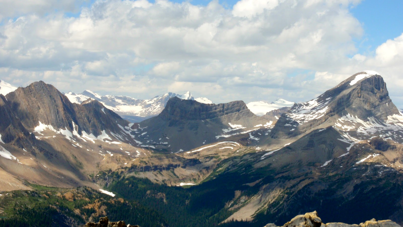
Being on Paget Peak, we had views of a whole row of glaciers and here is Mount Niles with Niles Glacier.
On our descent we stopped of at the edge where we had a view of Wapata Lake down below.
Edges and ledges are wonderful places to be for enjoying spectacular views but it doesn't always pay to "live on the edge" or close to it.  As the day has passed and we are now into the night as I share my day with you, I see my knees changing color and size right before my eyes.  There is no beauty in this scene!
This little incident did not in any way what-so-ever take away from me
feeling like I was
 "on top of the world" 
today!  

Wednesday, August 3, 2011

Scenic Point GNP Montana Aug 3

Once again, before hitting any trail, we checked in at the St. Mary Visitor Center for the latest conditions.  They seem to be changing on a daily basis due to snow slopes improving, or snow bridges getting worse or trails closed due to bears.  Our plan was for Scenic Point in East Glacier and we confirmed it was A.O.K.   We got a later start due to yesterday's big day and there were already lots of cars at the trailhead by the time we arrived. 
We hiked in the trees for a very short distance then the start of the 17 switchbacks began and this is where the views started immediately.  The trees along the slope were scraggly and the wild flowers were splendid.  While still in the same National Park, this side had a whole different look.
The trail was very obvious and totally clear of snow.  At about the third switchback, we could see the edge of Two Medicine Lake.  This area seemed much further ahead with snow melt then the St. Mary or Many Glaciers areas.  It was so wide open with no place what so ever to take refuge from the sun beating down.
As we worked our way up the switchbacks, we got to see deeper into the valley between Mount Henry and Appistoki Peak and the start of Appistoki Creek in the center of the valley.  
A few of us took a small detour up a rocky scree covered slope which added more elevation to be at a high point where we had this view.  We took a few minutes and a few snacks before descending to join the others again and then head off to our destination.
That's our destination, that very last rock that is sticking out at the far end!  This whole dome- like ridge is called Scenic Point.  Much of the elevation is already done at this point, we just need to traverse this slope then climb to the final rock formation.  
Once at our destination, this was the view!  Two Medicine Lake is plain to see, a portion of Upper Two Medicine Lake was visible and Dawson Pass is on the right.  We could also see the townsite of East Glacier and Browning in the other direction.
I joined others to have this view for lunch.  This is Lower Two Medicine Lake.
Shortly after our descent began, and while we still had a wide open view, I took a panorama shot with Two Medicine Lake being the center of attention.  It was a very quick trip down.  I was already thinking this is an area I would like to come back to.  It is not suppose to be as busy, and I was surprised at the number of other hikers on the trail.  I know the National Park now has three Ranger led hikes in East Glacier where they never did before so are promoting it and I can see why.  It has beauty of a different kind and still a rewarding area to hike in.
If you decide to give it a go, go prepared for wind and take lots of water if it's a hot day.  The drive too and from the trail head was an adventure, being a smaller version of the going-to-the-sun road, but with no guard rails and the sides of the road giving way in a few spots.  

This hike had great rewards for not too much of an effort distance or elevation wise.  Having a view like the one above in my panorama photo, how could you not feel like  you were "on top of the world!"

Tuesday, August 2, 2011

Piegan Pass GNP Montana Aug 2

After checking out maps, reading trail descriptions, reviewing shuttle times, then chatting with the Ranger at the St Mary Visitor Center about conditions, we came to a consensus that Piegan Pass would be our hike for today.  We agreed to keep our options open and assess as we went along and if conditions were safe, we would carry on further.  The selection was limited of safe places to hike where crampons, ice axes and knowledge of self arrest were not advised.  Yet, even after doing all the necessary homework, our day turned out to be a wild adventure!  

The Piegan Pass trail head is at the Siyeh Bend just before the last stretch up to Logan Pass.
We followed the creek for a short period then veered off into the forest for a few kilometers before reaching a wide open space where we would spend the majority of our time.  You can see the trail ahead of me which leads up to Piegan Pass.  Between where I am and where the trail ahead is, there were two short steep slippery snowy sections to traverse.
As we got higher, I kept looking back and at this point the view was great of Siyeh Bend in the center of the photo and that's where our cars are parked.
We reached the Pass and could see down in the valley on the other side.  The turquoise tarn nestled at the base of the wall was a pretty sight.  This was our lunch stop and where we took time to assess and discuss options.   A couple of other folks along the trail had some info to share but not much more then we knew already.  We decided to carry on and continue the assessing process as needed.
Looking at this eastern face of The Garden Wall, it was hard to imagine that on the other side of this is a long large wide grassy slope carpeted in wild flowers.
We can see for the next stretch that conditions are fine so begin our steep descent but switch backs and scenery make it an enjoyable and quick one.   At the end of this portion of descent, its time for one last longer rest to snack and enjoy the view before heading into the trees for the balance of the hike.  At this point, conditions have been great and still look great ahead, time is on our side, so we decide the Many Glacier Hotel will be our destination and we will catch the last shuttle from there back to St. Mary then transfer on to the Park shuttle to get back to our vehicles.
Not long after our longer stop, we come across a very steep slippery snowy slope that hasn't yet been crossed.  Others begin the traverse and I start to but just can't do it so take the three steps back and descend the steep slope on solid ground trying not to kill too many glacier lilies and thinking I will feel safer crossing over at the lower portion then climb back up on dry land on the other side.  As myself and my friend who sticks with me get lower, we see the trail on our side again.  We wait here for those that traversed across because they need to complete the switchback then traverse back again to reach the trail lower down.  At this point, we are waiting for them to appear and to watch them cross this slope.  One friend did loose their footing, tried to self arrest but couldn't and slide to the bottom landing in a drainage below a snow bridge but thankfully came away unscathed and O.K.  I couldn't watch the rest of them cross from that point on!
We finally reach Cataract Creek, our descent is done.  Now it is pretty much flat the balance of the way so can make up our time along this section.  This is a beautiful view looking back at where we were and Morning Eagle Falls in the middle of the photo but we need to cross the creek and we see the wooden bridge on the other side of the creek laying in a protected area in the bushes.  The Rangers have not been out yet to but the bridges back in place.  The creek is high and cold and fast and we walk it looking for options to cross.  We were warned about snow bridges and that some have collapsed and others are ready to do so.  This snow bridge is our only option to cross the creek at this point.   We assess it, test it out, then all make our way safely across.
We come across another place where the bridge is on the other side, and where the creek is wider, there isn't a snow bridge, so we need to do a bare foot crossing and all the assessing and the crossing take up time that now leaves us in rush mode to make the last shuttle at 5:30.    With 3.7 kms to go its serious business so heads are down, the pace is rush, voices are loud and we motor to the Hotel arriving at 5:08, thankfully with time to spare, so we think.  We find out the last bus left at 4:45!  No more shuttle runs, no cabs, no tour buses!  We are a long way from our vehicles which are almost at Logan Pass.  We talk with the Hotel Shuttle Hostess, who is able to contact a shuttle driver who is willing to come get us and take us to St. Mary but we have to wait an hour for him which is absolutely fine.  He drives us right to our camp site so we tip him big time.  I drove the two drivers from the morning up to Siyeh Bend, they hop in their vehicles and we all drive home!
It was great to be in an area away from the hoards of hikers where we could own the trail for the majority of the time.  I appreciate an area where the landscapes are varied and it is so wide open that you can see forever.  I really enjoy when the trek gets wild with unique situations that make for a memorable adventure! It pays to keep options open, to take chances and to explore because you can end up in places where you feel like you are "on top of the world!"

Monday, August 1, 2011

Hidden Lake GNP Montana Aug 1

For the third year in a row, I have chosen to spend a few days in early August at Glacier National Park in Montana.  This time would be different though in the sense I will be camping instead of hotelling it.  I set up camp yesterday at Johnson's Campground for four nights.  I arrived yesterday while my friends were out hiking Iceberg Lake and Ptarmigan Tunnel.  

This morning we stopped in at the St. Mary Visitor Center to check out trail conditions and to see if the Ranger could make a safe suggestion for us that didn't involve needing an ice axe and crampons and that was on the shorter side.  We came away with the decision to do Hidden Lake which I had done twice before but certainly didn't mind hiking it again.  

Once behind the Logan Pass Visitor Center where the trail head is, I thought it looked more like early spring time then the dog days of summer due to the amount of snow.  What wasn't covered with snow, was covered with glacier lilies.
The sticks in the snow marked the trail.  Under all the snow is a board walk with stairs and landings.  It was fun to watch people ahead of me wearing everything from hiking boots to sandals trying to make their way up the snow.
Most hikers opted to stop at the Hidden Lake Overlook and that was what the Ranger recommended but did say folks are going beyond but there are steep slippery snowy slopes and proper foot wear and hiking poles are a good idea.   The little black dots are people crossing the slope.   I bit the bullet and just went for it!  UGH!
On both previous occasions being here, Hidden Lake was totally melted but this time it wasn't and that made doing it a third time all worthwhile.  It looked so pretty with pieces of ice floating in it.
When we reached the lake side, the reflections were gorgeous.  We found a nice spot in the sun and rested for quite some time, ate, took lots of photos and played around the water.
What is going to Logan Pass and hiking Hidden Lake if you don't see a mountain goat?  It's part of the package deal!  The goat population is growing and this baby is trying to get through the snow to catch up to Mom.
Nearing the end of our hike,  Ranger Brady was ending his work assessing conditions along the trail so we stopped for a chat and a photo op.  He had interesting info to share and talked a bit about the story written in the book Night of the Grizzlies. (I picked up the book at the Swift Current Ranger Station before heading back to Calgary.)
The Hidden Lake trail conditions should improve over the next few days with the gorgeous hot sunny weather but I wonder if it will totally clear before the new snow starts to fall.  Today was a great start to this vacation and now we get to go enjoy happy hour at our campsite then dinner, more drinks and end the evening under the stars around a campfire.  Aahhhh, this is what life is all about!

Sunday, July 31, 2011

July's Ground Cover

I just realized after looking at what ground I covered in July, that all the hikes expect Mt. Lipsett on July 1st were in the National Parks.  While out covering ground this month, I saw lots of ground covered in wild flowers and some mountains covered in old snow while others were covered in new snow.  For the new snow that has fallen, I don't know whether to say "it's still snowing or it's snowing already!"  Considering camping is taking up some of my time, I'm pleased with my hiking tallies but not what I have to show for running or biking.  The total numbers are cumulative for the year.  

Thursday, July 28, 2011

Waking Wiser

This three day camping trip was an experiment, a quiet get-a-way, and an opportunity to grow and to learn by choice, even yet, also to become wiser for a reason which I have no control over.   My agenda was a very simple, sedimentary, slack one!  The only hard work I had was setting up my home away from home and the more I do this the easier it gets.  

Once I was moved in,  I quickly made myself at home!  
A "Tartan" and "Spooky Campfire Stories" by daylight set the tone for my get-a-way.  
I brought along lots of reading material to pass my time between meals and naps.   I like this add in the Backpacker magazine!  It says "navigate the unforgettable!"  Well, I did!  I saw the sun rise at Mesa Arch, I rappelled and canyoneered and I hiked to the Fisher Towers all during my trip to Moab in May of this year.  I learned lots about backpacking meals from this magazine that I will put to use.   
I have been curious ever since June of 2009, if the Letterbox is still there and how many more folks found it.  I went for a drive in hopes of remembering where it was and I did find it, only to learn just two others found it since we did.  
I didn't have to go far to see a variety of wild flowers in full bloom!  With in a ten minute walk around my Loop, there were plenty to see.  I did the Loop quickly between showers and was able to capture some of the flowers still with rain drops on them.  
While my fire didn't crackle much, it was enough of a campfire to do what campfires are suppose to do!  I was envious of my neighbours crackles'.   I am learning that it takes patience to get one roaring!
I tried new recipes on my Trangia which I learned will work great for my next trip.   While most of the get-a-way was quiet, I did meet my neighbor who is from Arkansaw and just finished a five day backpacking trip and was resting a couple of days before heading to do a seven day trip.  I could learn lots from him, he has been doing long backpacking trips for 40 years.

I came away wiser from this trip too!  Don't they say "the older the wiser"?
Thank you for the wishes!